Google Earth
 Google Earth is an interactive Globe where users can navigate by panning, zooming, and tilting the virtual globe.
They can explore different locations by entering place names, addresses, or coordinates. Enhancing students’ global perspectives has become incredibly easy, thanks to Google Earth!
This innovative platform enables instructors to transport their students on virtual expeditions to any corner of our planet, the moon, distant stars, and even the captivating landscapes of Mars.
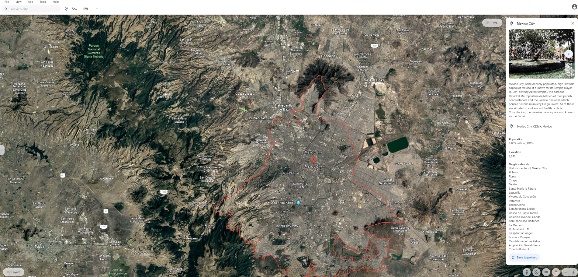 From exploring the abyssal depths of our oceans to scaling the majestic peaks of our highest mountains, Google Earth caters to the diverse interests of every academic discipline, offering lots of opportunities for immersive learning experiences. Google Earth provides high-resolution satellite imagery and aerial photography of locations around the world, allowing users to view landscapes, cities, landmarks, and natural wonders in detail. Toggle between 2D and 3D views to visualize terrain, mountains, valleys, and buildings in three dimensions.
The integrated street view imagery allows exploration of streets and neighborhoods at ground level, offering a realistic perspective. Google Earth offers historical imagery, allowing anyone to view past satellite imagery of locations and observe changes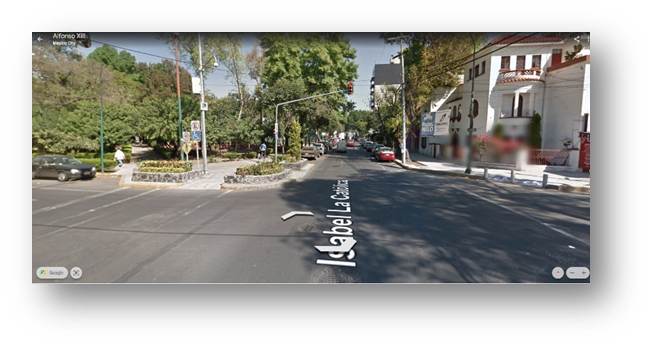 over time, such as urban development, deforestation, or natural disasters. Users can overlay additional information on the map using layers, including borders, roads, transportation networks, weather patterns, and points of interest. Google Earth also provides curated content, such as educational tours, geographic features, and cultural landmarks. It includes tools for measuring distances, areas, and elevations, as well as adding annotations, markers, and paths to customize maps and share information.
Google Earth is available as a desktop application and is also accessible through web browsers and mobile devices. With its extensive features and global coverage, Google Earth is a valuable tool for instructors, students, researchers, travelers, and anyone interested in exploring the world from a digital perspective.
Here are some ideas for incorporating Google Earth into the classroom:
- Virtual Field Trips: Take students on virtual field trips to explore geographical features, historical sites, famous landmarks, or ecosystems around the world. For example, visit the Grand Canyon, Machu Picchu, the Great Barrier Reef, or the Amazon Rainforest.
- Geography Lessons: Use Google Earth to teach concepts such as continents, countries, oceans, rivers, mountains, and climate zones. Have students locate and label geographic features or plot the routes of famous explorers and historical events.
- Cultural Studies: Explore different cultures, traditions, and civilizations by virtually visiting cities, monuments, museums, and archaeological sites. Compare and contrast architectural styles, urban planning, and cultural practices across regions.
- Environmental Science: Investigate environmental issues by examining changes in land use, deforestation, urbanization, and natural disasters using historical imagery and layers. Analyze the impact of human activities on ecosystems and biodiversity.
- History Lessons: Bring history to life by exploring historical maps, landmarks, battlefields, and ancient civilizations. Trace the paths of historical figures, explore significant events, and understand the context of historical narratives.
- Literature and Language Arts: Enhance literature studies by mapping the settings of novels, poems, or plays. Explore the landscapes described in literary works and discuss how geography influences characters and plotlines.
- STEM Education: Integrate Google Earth into science, technology, engineering, and math (STEM) lessons. Calculate distances, areas, and elevations using measurement tools. Explore geological features, plate tectonics, and natural phenomena like volcanoes and earthquakes.
- Social Studies and Current Events: Analyze geopolitical issues, conflicts, and current events by examining regions of political significance, borders, and cultural diversity. Discuss global challenges such as climate change, migration, and human rights.
- Project-Based Learning: Engage students in project-based learning activities, such as creating virtual tours, research projects, or multimedia presentations about specific topics or regions of interest.
- Critical Thinking and Problem-Solving: Encourage students to ask questions, make observations, and draw conclusions based on the information available on Google Earth. Develop critical thinking skills by analyzing spatial data, making predictions, and solving geographic puzzles.
Video: Google Earth for Beginners
https://youtu.be/3lGl1VZjtg4?si=mOHVnldaNjrUMwRs
By incorporating Google Earth into classroom instruction, instructors can provide students with interactive and immersive learning experiences that foster curiosity, exploration, and a deeper understanding of the world around them.
For more information send an email to gloria.barron@montgomerycollege.edu